 1 hour ago
1

Upgrade to High-Speed Internet for only ₱1499/month!
Enjoy up to 100 Mbps fiber broadband, perfect for browsing, streaming, and gaming.
Visit Suniway.ph to learn
October 22, 2026 | 7:15am
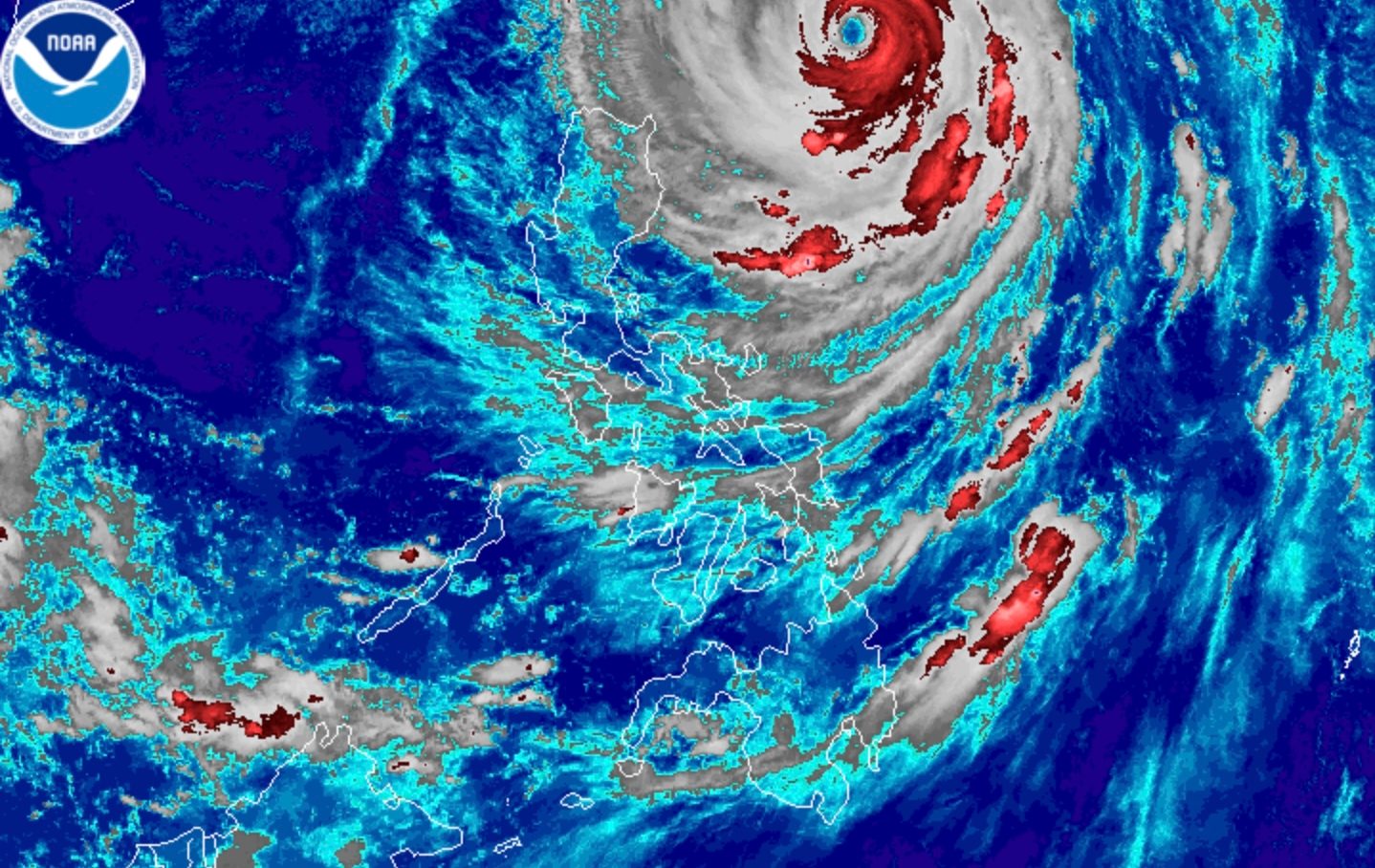
Satellite image from PAGASA showing Super Typhoon Rosal as of 4:40 a.m. on Oct. 22, 2026.
PAGASA / Released
MANILA, Philippines — Super Typhoon Rosal (international name: Champi) slightly weakened as it continued its northwestward track over the Philippine Sea east of Batanes, the state weather bureau PAGASA said.
As of 4 a.m. on Thursday, October 22, PAGASA said the center of Rosal's eye was estimated to be 495 kilometers east of Basco, Batanes.
Rosal now has maximum sustained winds of 195 kilometers per hour (kph) near the center and gusts of up to 240 kph, with a central pressure of 915 hPa.
It is moving northwestward at 20 kph, with Rosal’s strong to typhoon-force winds extending outward up to 780 kilometers from its center.
Despite its weakening, PAGASA maintained Tropical Cyclone Wind Signal No. 2 in two areas, where estimated gale-force winds of 62 to 88 kph pose a minor to moderate threat to life and property within 24 hours:
- Batanes
- Northeastern portion of the Babuyan Islands
Meanwhile, Tropical Cyclone Wind Signal No. 1 remains hoisted over the following localities, where strong winds of 39 to 61 kph are expected within 36 hours:
- Babuyan Islands: Remaining portion
- Cagayan: Mainland
- Isabela: Eastern portion (Maconacon, Divilacan, Palanan, Santa Maria, Cabagan, Delfin Albano, Santo Tomas, Tumauini, San Pablo, Ilagan City, San Mariano, Dinapigue)
- Ilocos Norte
- Apayao
PAGASA noted that Signal No. 3 remains the highest warning level that may be raised over Batanes during Rosal's passage. However, should the typhoon shift to a more north-northwestward track, raising Signal No. 3 will become less likely.
Rosal entered the Philippine area of responsibility at 2 a.m., according to PAGASA.
Track forecast
Rosal is projected to continue moving northwestward until Friday morning, October 23. It will turn north-northwestward by Friday afternoon before recurving north-northeastward by Saturday, October 24.
The typhoon is expected to make its closest approach to Extreme Northern Luzon between Thursday afternoon and Friday morning. It is forecast to exit the Philippine area of responsibility (PAR) by Friday evening or early Saturday morning.
The state weather bureau expects Rosal to continue gradually weakening throughout the day, with a potential downgrade to typhoon status.
Rapid weakening is expected by Saturday, when the cyclone may be further downgraded to a severe tropical storm.