Upgrade to High-Speed Internet for only ₱1499/month!
Enjoy up to 100 Mbps fiber broadband, perfect for browsing, streaming, and gaming.
Visit Suniway.ph to learn
Already have Rappler+?
to listen to groundbreaking journalism.
This is AI generated summarization, which may have errors. For context, always refer to the full article.
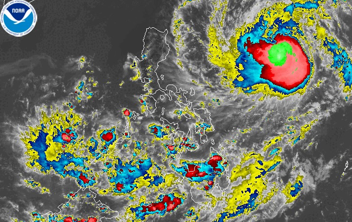
FRANCISCO. Satellite image of Typhoon Francisco (Mekkhala) as of June 21, 2026, 4 pm.
NOAA
Typhoon Francisco (Mekkhala) is located 1,055 kilometers east of Central Luzon on Sunday afternoon, June 21
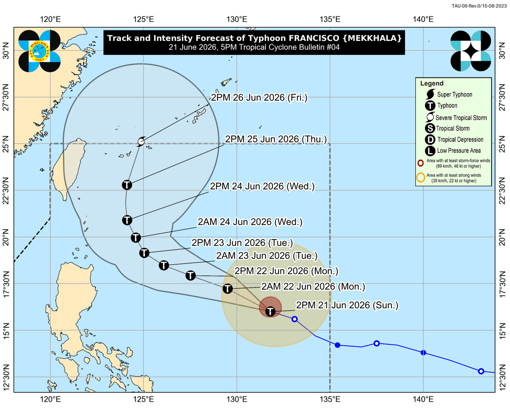
MANILA, Philippines – Francisco (Mekkhala) strengthened from a severe tropical storm into a typhoon at 2 pm on Sunday, June 21.
Francisco’s maximum sustained winds increased from 110 kilometers per hour to 120 km/h, said the Philippine Atmospheric, Geophysical, and Astronomical Services Administration (PAGASA) in a bulletin issued at 5 pm. Its gustiness is now up to 150 km/h from the previous 135 km/h.
As of 4 pm, the typhoon was located 1,055 kilometers east of Central Luzon, moving west northwest at 25 km/h.
PAGASA reiterated that Francisco is likely to remain over the Philippine Sea, but “a closer approach to extreme Northern Luzon” is possible if the typhoon’s track shifts further westward.
Francisco will also be enhancing the southwest monsoon or habagat. According to the weather bureau, the enhanced southwest monsoon may start bringing heavy rain to parts of Luzon and the Visayas on Monday, June 22. Specific rainfall advisories are expected to be issued.
In the meantime, on Sunday evening, the trough or extension of the typhoon may continue to trigger scattered rain and thunderstorms in Bicol. Similar conditions may also persist in Mindanao, the Visayas, and Palawan, but due to the southwest monsoon. In the rest of Luzon, there could be localized thunderstorms.
In anticipation of strong winds from Francisco, Signal No. 1 might be raised for portions of Cagayan, Babuyan Islands, and Batanes by Monday morning.
The southwest monsoon is also bringing strong to gale-force gusts to the following areas:
Sunday, June 21
- Siquijor, Camiguin, southern part of Bohol, Southern Leyte, Davao Oriental, Davao Occidental, Sarangani
Monday, June 22
- La Union, Pangasinan, Calabarzon, Romblon, Masbate, most of Visayas, Basilan, Sulu, Zamboanga Peninsula, Misamis Occidental, Lanao del Norte, Camiguin, Surigao del Norte, Dinagat Islands, eastern part of Davao Occidental, eastern and southern parts of Davao Oriental
Tuesday, June 23
- most of Luzon, Visayas, Zamboanga Peninsula, Northern Mindanao, Surigao del Norte, Dinagat Islands, Davao Occidental, Davao Oriental
In the next 24 hours, up to moderate seas are expected in these seaboards:
- Eastern seaboards of Isabela and Davao Oriental – waves up to 2.5 meters high
- Seaboards of northern Aurora and Surigao del Sur; eastern seaboards of Babuyan Islands, mainland Cagayan, Albay, Sorsogon, Eastern Samar, Dinagat Islands, Siargao Island-Bucas Grande Island Group, and Davao Occidental; northern and eastern seaboards of Catanduanes and Northern Samar; northern seaboard of Camarines Sur; southern seaboard of Davao Oriental – waves up to 2 meters high
Small vessels should take precautionary measures, or avoid sailing, if possible.
Francisco is the Philippines’ sixth tropical cyclone for 2026, and the second for June. It could leave the Philippine Area of Responsibility (PAR) on Friday, June 26.
Meanwhile, PAGASA is monitoring a new low pressure area (LPA) outside PAR, located 3,020 kilometers east of southeastern Luzon as of 3 pm on Sunday.
This LPA has a low chance of developing into a tropical depression within 24 hours. Further updates will be given in the coming days.
PAGASA had announced the onset of the southwest monsoon last May 30, and the start of the rainy season on June 4. – Rappler.com
How does this make you feel?
Loading